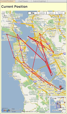
En el sitio de la empresa hay una página donde se puede ver las rutas que ha hecho el Zeppelin y la posición actual (mapas de Google Maps).
Por su estabilidad y su baja altura de vuelo, entre otros motivos, la NASA está probando usar Zeppelines como plataforma para distintos sensores remotos. Así, la NASA usaría los servicios de esta empresa, según leo en Spatial Sustain.
Airship Ventures, a zeppelin company that has been leasing space at Moffett Field outside San Francisco since 2008, now is being used by NASA as a platform for remote sensing and atmospheric science measurements. Airship Ventures leases its space at Moffett Field, which is run by NASA’s Ames Research Center. The Center’s Earth Science Division has begun collaboration with the company to take advantage of the airship’s stability, maneuveribility and ability to fly at low altitude for sustained periods of time.En la página de la Wikipedia, pueden ver la historia de estos gigantes del aire.
Scientists conducted an eight-hour test flight this week to conduct three separate experiments. The craft used a large-format camera and hyperspectral imager to study extremophile biota in the south bay salt ponds for the the Search for Extraterrestrial Intelligence (SETI) Institute, the distribution and density of harmful algae bloom organisms in Monterey Bay that are poisonous to wildlife for the Monterey Bay Aquarium Research Institute (MBARI), and searched for subsurface natural gas pipeline leaks for the Pipeline Research Corporation International (PRCI).
Fuentes:
Spatial Sustain
Airship Ventures
Zeppelin o Dirigible en Wikipedia.


No hay comentarios.:
Publicar un comentario