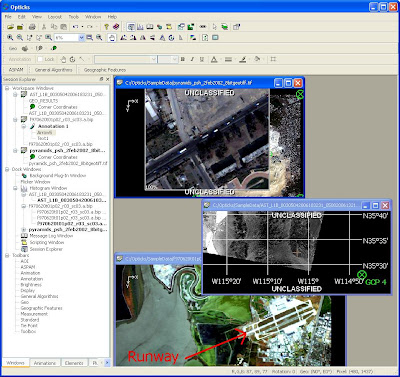
 Opticks es un programa Open Source para procesar y analizar imágenes y videos de sensores remotos. Con Optikcs se pueden procesar imágenes de satélites o fotografías aéreas tradicionales y también imágenes de radar (SAR) y, tal vez lo más atractivo, imágenes de videos así como imágenes multiespectrales e hiper espectrales. Las imágenes de video pueden ser tratadas como cualquier otra imágen de sensores remotos !!
Opticks corre en Windows XP, XP x64 y en Solaris 10 SPARC. También hay una versión no estable para Linux. Para crear Plug-Ins para Opticks existe un paquete de desarrollo (SDK, Software Development Kit) . Al pie copie las principales características del Programa.
Opticks tambien es un "remote sensing development framework" bajo licencia LGPL 2.1.
Opticks es un proyecto Open Source de Ball Aerospace & Technologies Corp, una empresa contratista del Departamento de Defensa de los Estados Unidos. El proyecto es bastante activo. Tengo instalada la versión la versión 4.2.0, liberada el 20 junio de 2008, y ya hay una nueva versión. Además, cada vez que visito el sitio del proyecto encuentro que hay novedades interesantes, mejoras en la ayuda online etc.
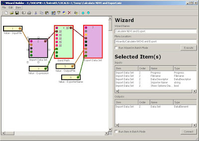
 La herramienta Wizard Builder sirve para hacer Scripts en una forma gráfica. El ejemplo lo tomé del sitio de Opticks y muestra la carga de una imágen, el uso de la calculadora raster (por ej para calcular NDVI), y luego exportar el resultado a una nueva imágen.
Los formatos de imágenes que Opticks puede importar son (extraído del Help):
- ASPAM Importer. Loads ASPAM and PAR files that follow the official ASPAM and PAR specifications as well as files that deviate from the standard in certain well-defined ways.
- Auto Importer. Allows you to import a data set without knowing which importer to use. Based on the file you choose, Opticks automatically selects the importer. If Opticks can’t find an importer, it automatically uses the Generic Importer.
- CGM Importer. Loads CGM objects into an annotation layer.
- DTED Importer. Allows you to load data in DTED format.
- ENVI Importer. Allows you to load spectral data that has an associated header file in ENVI format.
- ENVI Library Importer. The ENVI Library Importer is a signature importer, not a data importer. It is similar to the ENVI Importer but loads one or more signatures (as part of a spectral library) instead of a data set.
- Generic HDF5 Importer.
- Generic Importer. Allows you to import a data set without knowing the format. If you use the Generic Importer, you have to enter the values in the Import Options. Click on the Options button to display the Import Options window. Be sure you enter the appropriate values in the Spectral Cube Properties.
- GeoTIFF Importer. Allows you load TIFF files that include geocoordinates (latitude/longitude) information. Also loads plain TIF files.
- Geographic Feature Layer Importer.
- Hyperion Importer.
- Ice Importer. Allows you to load data in Opticks' native format. A data set must have already been exported with the Ice Exporter in order for a file to exist that you can load with this importer.
- Layer Importer.
- Model Importer.
- NITF Importer. Enables you to load data in NITF format.
- SIO Importer.
- Shape File Importer. The Shape File Importer enables ESRI shape files to be loaded into the current data set.
"Ball Aerospace's Opticks demonstrates how government-sponsored code originally developed by a contractor can be maximized by releasing it as open source," said John M. Weathersby, executive director of the Open Source Software Institute.Pueden ver un video de Opticks (se requiere flash) donde se muestra el uso de la herramienta Data Fusion para visualizar el cambio estacional de turbidez en agua usando imágenes LandSat 7 (ETM+).
Las principales características de Opticks son:
- Zoom, pan, rotate spatially large datasets.
- Quickly layer GIS features, annotations, results, and other information over your data to provide context.
- Link dataset geographically. Zoom and pan one dataset links to another.
- Product mode and annotations.
- Active annotations, including North Arrow, East Arrow, Scale Bar, and Timestamp
- Many image display controls, such as colormap, histogram, transparency, etc.
- User defined video/image processing "plug-ins".
- Support for datasets in excess of four gigabytes (64-bit support).
- In memory and on disk processing.
- Analysts can quickly combine steps using graphical wizards.
- Batch processing.
- Online Help
- Native support for many remote sensing file formats: NITF2.0/2.1, ASPAM/PAR, CGM, DTED, ENVI, Generic RAW, ESRI Shapefile, HDF5, AVI, MPEG, JPEG, GIF, PNG, BMP, TIFF, GeoTIFF.
- Connect to Geodatabases with ESRI ArcSDE integration.
- Support for Microsoft Windows ( 32-bit and 64-bit ) and Solaris SPARC operating systems.
- Pan, zoom, rotate, and geo-referencing spatially large video.
- Playback multiple video datasets synchronized by time.
- Overlay geographics features and have them georeference per frame, moving as you playback.
- Support for multiple spectral dataset formats including BIP, BSQ, and BIL.
- Support for 1000's of spectral bands.
- ENVI signature importer.
- Principle Component Analysis.
- Native support for complex data.
- Display as Phase, Magnitude, In-phase (I), and Quadrature (Q).
Opticks Project Home
Ayuda y Tutoriales Online de Opticks
Vean el video aquí.
Aquí pueden acceder a imágenes ASTER y LandSat para probar Opticks.
Ball Aerospace & Technologies Corp Home
Government Computer News: Open source remote sensing


